Rochdale Harriers Coast-to-Coast Relay
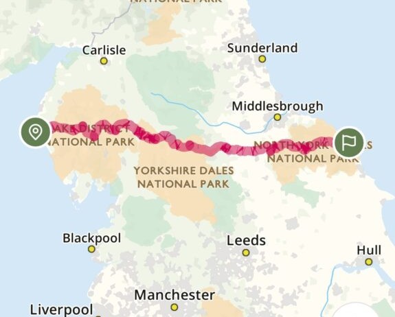
On 26th June 2025 we begin a continuous, relay run of the entire Wainwright coast-to-coast route (“C2C”). The C2C crosses the entire width of England. It starts at St Bees near the Irish sea and passes through mountains and remote paths before finishing at Robin Hood’s Bay, near the North Sea (about 6 miles North of Whitby). The total distance is about 192 miles and the ascent is about 28,000ft. The route is shorter than our 268 mile/37,000ft Pennine Way Relay in 2024, but the entire route is pretty far from Rochdale and that creates some extra challenges. This event is available only to paid-up members of Rochdale Harriers & A.C..
We have broken the route into 21 legs, as shown in Table 1 below. This takes us through the Lake District and Cumbria, the Yorkshire Dales, the Vale of Mowbray, and the North York Moors. At the time of writing, 48 Harriers were interested and at least 2 will run together on each leg. About 30 members are interested in a night out in Whitby afterwards.
Taking part is a big commitment. None of the legs are near Rochdale and this may create practical difficulties for some Harriers. The arrangements will be similar to the PWR (e.g. you will need to recce your section, wear or carry full fell kit, sign entry form and disclaimer, provide a completed PARQ form, min age 18 (although members aged 16 and 17 can run up to 20km off-road with their parent or guardian) and be a fully paid-up member of the Club).
Table 1 – Legs
| Leg Number | Leg Name | Distance (miles) | Ascent (ft) | OS Map | Comment |
|---|---|---|---|---|---|
| 1a | St Bees to Sandwith Crossroads | 4.2 | OS Map | Undulating. | |
| 1b | Sandwith Crossroads to Ennerdale Bridge | 10.5 | OS Map | Very hilly. Leg 1a + 1b has 2,884 ascent with most in 1b. | |
| 2 | Ennerdale Bridge to Rosthwaite | 14.75 | 2,238 | OS Map | |
| 3 | Rosthwaite to Grasmere | 8.25 | 1,936 | OS Map | |
| 4 | Grasmere to Patterdale | 7.75 | 1,910 | OS Map | |
| 5a | Patterdale to Bowderthwaite Bridge (ends at NY 46793 11783) | 6.5 | 3,633 minus the 5b climb | OS Map | Contains almost all of the climb |
| 5b | Bowderthwaite Bridge to Shap | 9.25 | OS Map | Gently undulating with not much ascent | |
| 6 | Shap to Orton | 8 | 1,026 | OS Map | |
| 7 | Orton to Kirkby Stephen | 12.75 | 1,275 | OS Map | |
| 8 | Kirkby Stephen to Keld | 11.5 | 2,130 | OS Map | |
| 9 | Keld to Reeth | 11 | 1,972 | OS Map | |
| 10 | Reeth to Richmond | 10.5 | 1,245 | OS Map | |
| 11a | Richmond to Bolton-on-Swale (end at SE 25081 99283) | 7 | 250 | OS Map | End car park on Back Lane (SE 24887 98776). Mostly downhill |
| 11b | Bolton-on-Swale to Danby Wiske (start at SE 25081 99283) | 7.25 | 250 | OS Map | Start car park on Back Lane (SE 24887 98776) Mostly downhill |
| 12 | Danby Wiske to Osmotherley | 11.5 | 895 | OS Map | |
| 13 | Osmotherley to Clay Bank Top | 11 | 2,727 | OS Map | |
| 14 | Clay Bank Top to Blakey Ridge | 8.75 | 884 | OS Map | |
| 15a | Blakey Ridge to Glaisdale | 8 | OS Map | All downhill | |
| 15b | Glaisdale to Grossmont | 5.2 | OS Map 1 OS Map 2 | ||
| 15c | Grossmont to B1416 (NZ 90706 03951) | 7.5 | OS Map | ||
| 16 | B1416 (NZ 90706 03951) to Robin Hood’s Bay | 7.6 | Approx. 1,000ft? | OS Map | |
| Totals | 192 | 28,140 | Est. 40 hours |